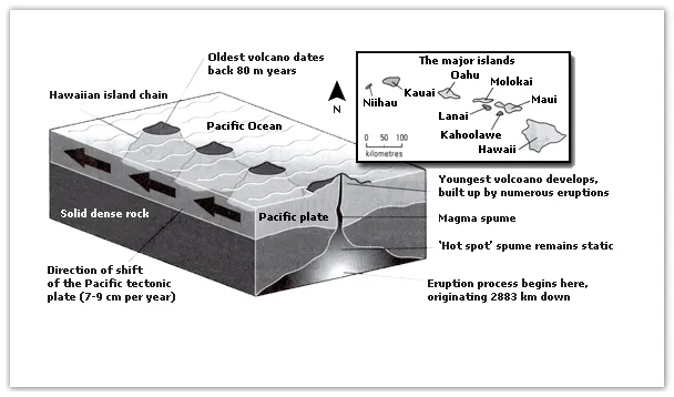
The provided diagram illustrates the geographical and geological aspects of the Hawaiian island chain, located in the heart of the Pacific Ocean.
The overview of the diagram reveals that the Hawaiian islands are formed due to volcanic activity, and the chain of islands stretches from southeast to northwest. It also shows that the islands are located at different distances from the hotspot, which implies varying levels of volcanic activity.
In detail, the southeastern part of the chain, where the island of Hawaii is situated, is directly above the hotspot, resulting in active volcanoes. This is evident from the presence of Mauna Loa and Kilauea, two of the world's most active volcanoes. Furthermore, the diagram indicates that the island is still expanding due to continuous lava flow.
Moving northwest along the chain, the volcanic activity decreases. For instance, Maui, the next island in the chain, has a dormant volcano, Haleakala. Further northwest, the islands of Molokai, Oahu, Kauai, and Niihau do not have any active or dormant volcanoes, indicating that they have moved away from the hotspot over time. This suggests a correlation between the proximity to the hotspot and the volcanic activity on the islands.